Sale Price $4.45.
Original Price $4.94 Comp. value
per card
You save 10%
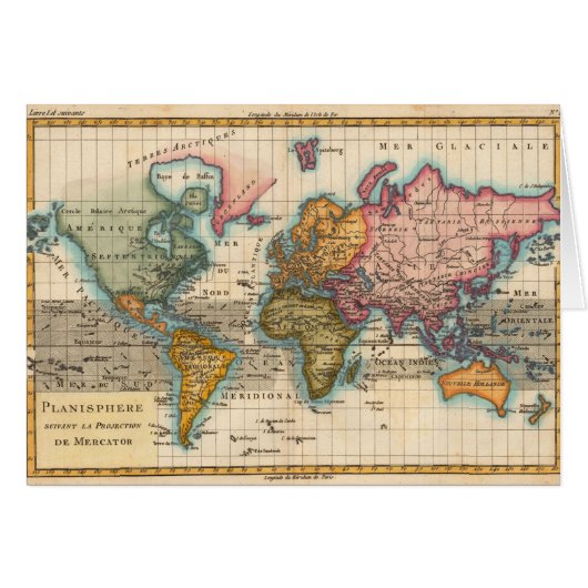
World Map 1700s Antique Continents Cards
View Product DetailsAbout Cards
Sold by
About This Design
World Map 1700s Antique Continents Cards
World Map from the 1700s -- the Planisphere A highly colorful world map from the 1700s, this world map print is from an authentic map originally published in 1780. It shows the world in vibrant full color. The world map continents are quite well rendered for being drawn 250 years ago. This beautiful world map's illustrator drew North America in green. Central and South America are in a bright yellow, Africa is a dark green, Europe and Australia in orange, and Asia and Greenland in pink. Beautifully rendered, this world map is a gorgeous image from a time when map making was an art. About "The Planisphere" world map image- The actual title of the image is "Planisphere Suivant la Projection de Mercator", published in Paris by M. Bonne in 1780. The Planisphere world map was originally printed as a copper engraving, and later hand colored in outline and wash.

Customer Reviews
4.9 out of 5 stars rating7.3K Total Reviews
7,347 Reviews
Reviews for similar products
5 out of 5 stars rating
By K N.November 10, 2018 • Verified Purchase
Folded Card, Size: Standard (5" x 7"), Paper: Signature Matte
Creator Review
What strikes me most about this card on opening the envelope is the stunning color and the beautiful close up. The card itself lends it to a feel good touch as well so its a lot of senses perked! My customers like it as well! The color is stunning! The closeup is very nicely detailed and just perfectly awesome! Could not ask for better printing!
5 out of 5 stars rating
By NavinJOSHI s.August 13, 2013 • Verified Purchase
Folded Card, Size: Standard (5" x 7"), Paper: Signature Matte
Creator Review
Unusual color scheme is clearly visible on the art. Not many artist try to emphasize that as an artist they can see things different so long they look beautiful. This is an UNIQUE image.
I bought a bunch of 34 different cards as like to give a different card to each of my friend which makes it very personal. When friends talk with each other, they appreciate the gesture all the more. Also I took advantage of volume pricing. Thanks to Zazzle for allowing to order even one card. I recommend people to buy from Zazzle. Pure Joy. Excellent printing and color tones.
5 out of 5 stars rating
By K N.November 10, 2018 • Verified Purchase
Folded Card, Size: Standard (5" x 7"), Paper: Signature Matte
Creator Review
iI am overjoyed and tickled pin with this card!! he minute I oened the envelope and saw it it just raised my spirits! Love the feel of the paper, its high quality all the way! And my customer really appreciaed it!! And topping that paired up with the labels was a perfect match! The color and the entire card and design is perfect! Better than I hoped and so awesome! My customer appreciiated it too! And the labels matched in color perfecty too!
Tags
Other Info
Product ID: 137458778329152694
Created on: 6/21/2012, 2:37 PM
Rating: G
Recently Viewed Items