About
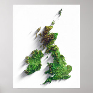
Have you ever looked back on photos from a trip, or retraced your route on a map and been underwhelmed? The hill you climbed seems so small, or the valley you drove down seems so flat. I love looking at maps, and though they’re great for navigation, they’re very bad at capturing the feeling of a location. They flatten important features of the terrain, like hills, ridges and valleys, that we instinctively recognise and remember when we’re there. In an effort to capture the magic of travel through amazing landscapes, I’ve refined a technique to represent the terrain in an ultra-realistic print, which exaggerates these important features, and using real satellite imagery. The result is a breathtaking interpretation of the terrain, which is much closer to the experience of seeing it than any photo or traditional map.
This beautiful effect is achieved by using digital elevation model data from the Copernicus satellite, combined with satellite imagery, which is then processed using 3D software, rendered and then printed on high quality matte paper (200 gsm) at very high resolution (300 dpi).
More
Latest Products Created
View All Products
British Isles terrain relief map print
Sale Price $54.36. Original Price $60.40. Comp. value
British Isles terrain relief map print
Sale Price $37.22. Original Price $41.35. Comp. value
Products
View All ProductsSave 10%
British Isles terrain relief map print
Sale Price $54.36. Original Price $60.40. Comp. value
Save 10%
British Isles terrain relief map print
Sale Price $37.22. Original Price $41.35. Comp. value
CREATOR